Fundamentals
Compaction occurs due to a pressure decline (often associated with fluid production), which causes the effective stresses to increase and a highly deformable rock to compact. Formation compaction occurs independent of the produced fluid type – whether hydrocarbons or water – and many of the most notable compaction events (Mexico City, US Gulf Coast, Venice) are driven by groundwater withdrawl.
There are three primary contributors to significant compaction (i.e., inelastic compaction):
- • High formation compressibility (often reflected as high porosity);
- • Significant formation (compactable) thickness; and
- • Significant pressure decline (i.e., increase in normal effective stress).
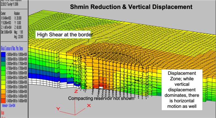
While compaction is the thinning of a depleted subsurface formation, compaction results in downward movement of the overlying formations. Depending upon the magnitude of vertical compaction and the aerial extent of the compacting region, the overlying formation movements may translate to a surface depression or surface subsidence.
The translation of reservoir compaction and overburden stress/strain changes through to surface subsidence may reactivate overburden faults or create bedding slippage effects. In addition, surface subsidence can affect surface structures such as buildings, roadways, offshore platforms and pipelines.
Reservoir Compaction and Subsidence Modeling
While early compaction and subsidence evaluations were conducted with simple analytical models, proper reservoir compaction and subsidence evaluations require a full-field, 3D geomechanical mechanistic model in order to to evaluate:
- • Subsidence magnitudes and timing;
- • Casing deformation evaluations (reservoir and overburden); and
- • Overburden frac gradient (stress) changes.
Subsidence Due to Underground Storage
Like subsidence due to reservoir compaction, surface subsidence due to the collapse (or partial) collapse of underground structures (e.g., salt cavern) also requires complex numerical modeling as well as detailed data with which to populate the model.
At OFG we understand and can develop the critical input data for a geomechanical compaction and subsidence model – with a special focus on establishing what drives the magnitude of subsurface deformations (formation compaction or cavern deformation and collapse).


Flow Model – Geomechanics Model Coupling
Model “coupling” is typically considered to be the linking of a flow model and a geomechanical stress-strain model. “Uncoupled” modeling occurs when the models are run completely separately, while “coupled” models (partial or fully) involve an exchange of data (primarily pressure from the flow model to the geomechanics model and, perhaps, stresses or deformation back to the flow model.
Where appropriate, OFG uses geomechanical simulators in combination with fluid flow simulations coupled (1-way, 2-way or iterative) to determine reservoir compaction and surface subsidence. The models are then calibrated/validated with measurements at the surface (e.g., Insar, GPS or bathymetry of the sea floor) or downhole (compaction measurements).